
Enlisted, Active Duty, Army Reserve, National Guard, Entry Level
Overview
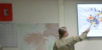
The geospatial intelligence imagery analyst is responsible for analyzing overhead and aerial imagery developed by photographic and electronic means. They provide Army personnel with critical information about enemy forces, potential battle areas and combat operations support.
Job Duties
•Produce intelligence by analyzing images, fixed/moving targets and geospatial data
•Identify military installations, facilities, weapon systems, military equipment and defenses
•Determine the location and dimensions of objects
•Conduct Battle Damage Assessment
Requirements
Those who want to serve must first take the Armed Services Vocational Aptitude Battery, a series of tests that helps you better understand your strengths and identify which Army jobs are best for you.
Training
Job training for a geospatial intelligence imagery analyst requires 10 weeks of Basic Combat Training and 22 weeks of Advanced Individual Training with on-the-job instruction. Part of this time is spent in the classroom and in the field.
Some of the skills you’ll learn are:
•Planning overhead and aerial imagery collection
•Preparing maps, charts, reports and Geospatial-Intelligence
•Using computer systems and imagery exploitation software
•Analysis of fixed/moving target indicators, geospatial data and overhead/aerial images
Helpful Skills
•Interest in reading maps and charts
•Gathering information and studying its meaning
•Ability to think, speak and write clearly
Helpful Skills
•Interest in reading maps and charts
•Gathering information and studying its meaning
•Ability to think, speak and write clearly
Helpful Skills
•Interest in reading maps and charts
•Gathering information and studying its meaning
•Ability to think, speak and write clearly
Related jobs
Geospatial Engineer (12Y)
Geospatial engineers are responsible for using geographic data that supports military/civilian operations for Disaster Relief and Homeland Security. They collect, analyze and distribute geospatial information to represent the terrain and its possible effects.
Active/Reserve: Both
Officer/Enlisted: Enlisted
Fore more information click here
No comments:
Post a Comment